Accepted Students ONLY!
Join us Saturday, March 28 (10 AM–2 PM) for Go Big BLUE DAY — sessions, tours, and giveaways.
Sign Up Today!
Students from the Interdisciplinary Studies in Geographic Information Systems (GIS) program participated in the 23rd Annual GIS/SIG Spatial/Digital Mapping Conference in the Rochester area held on April 15.
Jonathan Townsend, a graduate student in Biology, presented his master's degree research on bat conservation using acoustic sampling and GIS. Joel Van Dick, a senior Communication major and GIS minor, presented his GIS internship work for the City of Dunkirk.
GIS minors from Economics, Environmental Sciences and Geosciences also attended the conference and connected with GIS professionals from around the region, including SUNY Fredonia alumni.
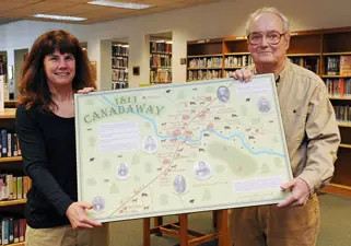
Fredonia alumnus Bryan Wilson (Environmental Sciences '05), shared first place in the Professional Map category with Geosciences faculty member Dr. Ann K. Deakin and English emeritus faculty member Dr. Douglas H. Shepard.
Wilson, an engineer with the South and Center Chautauqua Lake Sewer District, submitted his map of the Conewango Creek Water Trail. Drs. Shepard and Deakin's map reflected what Fredonia, known as Canadaway in 1811, looked like. The map will be donated to the Barker Library in Fredonia.